MarineTraffic or Voice GPS: Which Map Fits Your Trip?
I’ll sort out which app to open for a harbour visit or a drive, so you can choose the right map before you leave.
Iris TennantReviewer · published Nov 9, 2026 · 6 min read
01A harbour stop changed which map I needed
I was sorting the family calendar when a waterfront stop landed beside an errand across town. I wanted to know what ship we might see from the quay; I also needed to get us there by road. Those are separate jobs, even though MarineTraffic - Ship Tracking and Voice GPS, Directions & Maps both sit in Maps & Navigation.
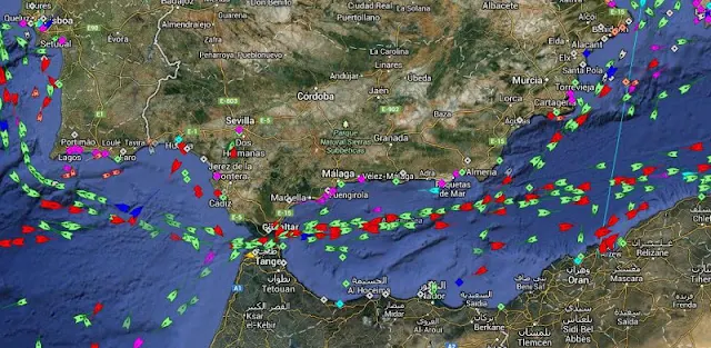
MarineTraffic is built around vessel positions, ports and shipping routes. Voice GPS is presented as a driving-directions app with voice navigation. I would choose between them by asking what needs to move on my screen: a ship at sea or my route through streets. The comparison below applies that same question to each app.
For my outing, that means I would use MarineTraffic while choosing a place to watch the water, then switch to a driving app when it is time to leave. Neither app’s category label tells that story as clearly as the map each one is meant to show.
MarineTraffic wins when the question is “Which vessel is that?” Its live map lets me search for ships, boats and seaports, or look at vessels nearby. At a harbour, I would start with the port and tap a vessel rather than try to identify it by its shape from shore.
Voice GPS wins for the road question: “How do I drive there?” Its stated purpose is GPS maps, driving directions and voice navigation. I would use it when the destination is a car park or meeting point, not when I want the name of a boat passing that point.
This is also why I would keep both jobs separate in a trip planner. A waterfront destination belongs in the driving plan; the vessel I hope to see belongs on MarineTraffic’s map. Entering the same place in each app may serve a different purpose, so I decide what I need before opening either one.
03At the quay, MarineTraffic has the useful details
MarineTraffic offers port arrivals and departures, estimated vessel arrival times and current port conditions. If I were planning a stop near a marina, I would check its port screen before promising the children a particular sight. An estimate is a planning clue, though, not a reason to time the whole afternoon to the minute.
I also like the practical distinction between a vessel’s present position and its track. MarineTraffic has animated playback, so I can look at where a ship has travelled as well as where it appears now. Voice GPS is the better pick for spoken road directions, but it is not the app I would open to follow a vessel.
MarineTraffic’s live wind layer and wind forecasts add context when I am looking at activity on the water. I would treat them as map information for the visit, not as a substitute for checking conditions before any water-based plans. For the drive to the quay, voice guidance matters more than wind on a marine map.
04When you need spoken turns, pick the road app
The strongest reason to choose Voice GPS is in its name and description: driving directions with voice navigation. Once I have chosen a destination, spoken guidance is the feature I want while the phone stays where I can glance at it safely. MarineTraffic’s vessel search cannot replace directions along streets.
The same distinction holds on a bigger journey. I might use flights or a car rental to reach a coastal town, but those plans do not change what each app is for once I arrive. Voice GPS is the road-navigation choice; MarineTraffic is the water-traffic choice when the harbour itself becomes the attraction.
I would settle the driving destination before setting off, then put my attention back on the road. At the waterfront, I can stop and explore MarineTraffic’s map without trying to manage a route at the same time. That handoff is simpler than expecting one map to do both jobs.
05MarineTraffic’s extras help if ships are the point
If I spot a vessel on the horizon, MarineTraffic’s Augmented Reality tool offers another way to identify it: point the camera toward the water to see vessel information such as its name, flag and speed. The latest notes describe a fix for Augmented Reality, which makes that tool worth checking if it interests you.
For a ship I want to follow again, I would put it in My Fleet rather than repeat a search each time. MarineTraffic also has ship and harbour photos, useful when a name alone does not help me recognise what I am seeing. These features make sense for repeat harbour visits, not for finding the next road turn.
Some MarineTraffic options are paid, including satellite tracking for vessels beyond land-based AIS receiver range and subscriber map layers such as nautical charts. I would begin with the live map and port information, then consider extras only if a specific vessel or route calls for them. A casual waterfront visit need not start in the purchase screen.
06Check the limits before planning around a dot
MarineTraffic draws on land-based AIS receivers across major ports and shipping routes, with satellite tracking offered as an additional option. That helps me read its map sensibly: a vessel icon is useful information, but I would not assume every stretch of open water has the same coverage as a busy port.
I make a similar distinction with an estimated arrival. If a ship is the reason for our outing, I would check its position and the port’s arrivals close to the visit rather than build the family calendar around an earlier estimate. Voice GPS answers the separate question of how to reach our chosen viewing spot.
This is where the side-by-side view matters most. MarineTraffic offers more detail about ships and ports; Voice GPS is aimed at getting a driver to a destination. The better app is not the one with more map layers. It is the one whose information matches the decision I need to make next.
07Choose by the next decision, not the app category
Pick MarineTraffic if you want to identify a ship, follow a vessel, check a port arrival or explore traffic along the coast. I would open its live map first, search the port or vessel, and use the extra layers only when they answer a real question. That is the clear winner for a harbour-focused outing.
Pick Voice GPS if the immediate job is driving directions with spoken guidance. Set the destination while stopped, then let the road route be the focus. If your day includes both a drive and ship-watching, I would use Voice GPS to get there and MarineTraffic once I am at the waterfront.
I would not choose either one as an all-purpose travel organiser. A trip planner can hold the itinerary, while these apps answer narrower questions along the way. Decide whether your next question is about a road or a vessel, and the choice becomes much easier.
The takeaway
First, name the thing you need to locate: a road destination calls for Voice GPS; a vessel or port calls for MarineTraffic.
For a closer look at the ship map, continue to this site’s MarineTraffic page just below.
Small Practical Wins is independent and not affiliated with MarineTraffic Applications. This guide reflects the reviewer's own setup; menus can differ by device and version.

 Best picksHubspace

 TipsAmazon Fire TV

 TipsAthan

 CompareAirbnb

 How-toParkNYC powered by
 CompareSaily

 CompareInstant Voice Translate

 How-toUNIQLO

 TipsFood City
 TroubleshootingNotes

 TipsGmail